Pattern change now looks likely bringing colder and some unsettled weather for a time but how long will it last?
The weather has been dominated by high pressure in the South of the UK over the last two weeks which has brought very mild SW winds into the UK but this is going to change from the weekend.
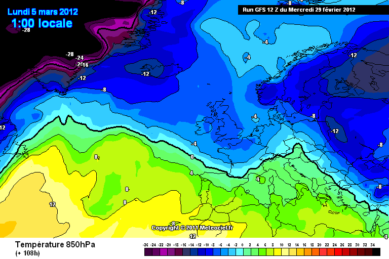
A cold front will move towards the UK on the weekend bringing a change to more colder conditions. This feature will introduce a cold airmass with 850hPa temperatures of below -5c and also some precipitation however any details are uncertain at the moment. But what is likely is that there will be a considerable drop in temperature compared to what we have been used to as of late with temperatures struggling to 5/6c in the west and maybe 5-8c in the East and snow is possible but this is only really likely on any higher ground in the north and west.
850hPA temperatures for Sunday
The length of this cold spell is still currently uncertain however a change to colder, sunnier with wintry showers looks likely from the weekend but temperature look to rise by the middle to end of the next week but this is likely to change.
Regards,
Matthew
Wednesday, 29 February 2012
Sunday, 26 February 2012
Weather for the week ahead - Monday 27th February - Sunday 4th March 2012
Springlike week again. Very Mild for most of the week, but Rain in some Northern and Western Areas, mainly dry with some sunny spells at times in the South and East. It may turn more unsettled by the weekend but confidence on this is low.
For Tuesday, Western coasts of Wales and England and Scotland may see patchy drizzle and mist or fog patches but some bright spells also at times. Everywhere else, any cloud should break late morning leaving Sunny spells and plenty of dry weather. Mild again and even warm where any cloud does break and temperatures could reach 17c but 11 or 12c on western coasts.
Confidence becomes low for beyond Friday but at the moment, Showers will affect Scotland and Northern England but should clear during the day bringing drier weather. Southern parts of England and Scotland will be dry for maybe all of the day. Maximum Temperatures at 9-14c
This is when the confidence really does start to fall for the forecast for the weekend, but more unsettled weather looks more likely. Saturday, England and Wales should be mainly dry with some sunshine through southern and eastern areas again. Rain may creep into the West later Maximum temperatures of 8-13c. Low confidence again for Sunday but a more unsettled day and turning colder with rain for most areas, heaviest in the West but this could easily change. Rain possibly snow on hills with maximum temperatures of 5-9c
The weather in Pembrokeshire last week was pretty awful with drizzle/mist/fog nearly every day of the week and unfortunately this week does not look that promising either compared to the rest of the UK. Patchy light rain and drizzle will be back but there will be some drier brighter interludes also and it will be staying very mild still but not as mild as E Wales and England.
Here are the min and max temperatures and also rainfall for the next 2 weeks for London and the second for Glasgow. However, these are likely to change, especially after the 4/5 day timeframe but a drop in temperature looks likely from this weekend.
Monday will bring a mainly cloudy day for most of the country. Southern England and East Wales should have a dry day however West coasts will probably see drizzle by the afternoon. Rain will affect Scotland and most of northern England during the afternoon and this should die out as it spreads South and East. Maximum Temperatures of 9-12c. Monday night, drizzle still affecting western coasts. Rain for Northern and Western Scotland but Eastern and Southern parts of Scotland should stay dry. Minimum temperature of 5-9c
For Tuesday, Western coasts of Wales and England and Scotland may see patchy drizzle and mist or fog patches but some bright spells also at times. Everywhere else, any cloud should break late morning leaving Sunny spells and plenty of dry weather. Mild again and even warm where any cloud does break and temperatures could reach 17c but 11 or 12c on western coasts.
For Wednesday, Western coasts of the country will see the cloudiest conditions again, The rest of the UK will be very mild day with a good deal of cloud but also some sunny spells nearly everywhere. Maximum temperatures of 11-15C.
On Thursday, fronts will move eastwards bringing some rain to western Scotland. Drier further south with high pressure still in place here but there may be some drizzle at times again on west coasts of Wales and northwest England. Eastern and southern areas should be mainly dry with some sunny spells across southern and eastern England. Maximum Temperautures of 10-15C.
Confidence becomes low for beyond Friday but at the moment, Showers will affect Scotland and Northern England but should clear during the day bringing drier weather. Southern parts of England and Scotland will be dry for maybe all of the day. Maximum Temperatures at 9-14c
This is when the confidence really does start to fall for the forecast for the weekend, but more unsettled weather looks more likely. Saturday, England and Wales should be mainly dry with some sunshine through southern and eastern areas again. Rain may creep into the West later Maximum temperatures of 8-13c. Low confidence again for Sunday but a more unsettled day and turning colder with rain for most areas, heaviest in the West but this could easily change. Rain possibly snow on hills with maximum temperatures of 5-9c
The weather in Pembrokeshire last week was pretty awful with drizzle/mist/fog nearly every day of the week and unfortunately this week does not look that promising either compared to the rest of the UK. Patchy light rain and drizzle will be back but there will be some drier brighter interludes also and it will be staying very mild still but not as mild as E Wales and England.
Here are the min and max temperatures and also rainfall for the next 2 weeks for London and the second for Glasgow. However, these are likely to change, especially after the 4/5 day timeframe but a drop in temperature looks likely from this weekend.
Have a good week,
Matthew
Thursday, 23 February 2012
Very Mild day for parts of the UK for this time of year with temperatures reaching 19c
Unusual temperatures for this time of year across many parts of Central and Eastern England today as temperatures hit 18.7c.
The record for Feb is 19.4c in 1891. Not all places enjoyed the sunshine however and places where it stayed misty and cloudy all day, temperatures struggled to get above 12c but this is still mild for this time of year with the average only around 8c. These temperatures are in huge contrast to the -18c we saw in the same places around two weeks ago.
This radar picture highlights where the cloud broke and this is where the warmest temperatures occurred.
For the rest of the week and weekend, mild weather will continue to dominate but not as mild as today.
Tonight, A band of rain will spread southeastwards, reaching northern England by the morning. Cooler conditions will follow, with showers across Scotland. Largely dry to the south, but western parts will continue to see patchy drizzle and hill fog at times. Lows 6-10c but maybe 2c in Northern Scotland.
Tomorrow, rain continuing southwards across parts of southern England and Wales. Brighter but colder to the north, with blustery showers in the far north. Still quite windy today particularly across Scotland and It will remain quite mild across central and southern parts of England but elsewhere it will be a bit cooler. Light patchy rain across Southern England and Wales in the afternoon will clear in the night leaving drier, cooler and clearer conditions, taking longest to reach the South East. Most of Scotland and Northern Ireland will have a dry day with sunny spells although a few scattered, mainly light showers are expected to run into northwest Scotland on the brisk west winds. As the winds drop we may see some fog patches developing along with a slight ground frost in places. High temperatures today of 3 to 6C across Scotland and Northern Ireland, 8C for northern England but 11-14C across southern England and Wales.
For the weekend, Most places will be fine after a chilly start Saturday. Sunday should be dry and fine aswell with fairly light winds and highs of around 10c/11c. Further spells of rain spreading east Sunday night and Monday, easing as they do so. Breezy and staying fairly mild with highs of 7-11c, coldest in the North.
Pembrokeshire will start off dry tomororw but mainly cloudy but rain and mist will arrive again by the afternoon with highs of 11c . Mainly dry saturday with sunny spells but rain spreading East late Sunday evening and Monday.
So starting to feel like Spring now across many areas and this winter is coming to a close however cold conditions are still possible during March with some quite severe cold spells in March in the past. The drought across the South East and Midlands looks set to continue with little rain expected in next few weeks at the moment.
Regards,
Matthew
The record for Feb is 19.4c in 1891. Not all places enjoyed the sunshine however and places where it stayed misty and cloudy all day, temperatures struggled to get above 12c but this is still mild for this time of year with the average only around 8c. These temperatures are in huge contrast to the -18c we saw in the same places around two weeks ago.
This radar picture highlights where the cloud broke and this is where the warmest temperatures occurred.
For the rest of the week and weekend, mild weather will continue to dominate but not as mild as today.
Tonight, A band of rain will spread southeastwards, reaching northern England by the morning. Cooler conditions will follow, with showers across Scotland. Largely dry to the south, but western parts will continue to see patchy drizzle and hill fog at times. Lows 6-10c but maybe 2c in Northern Scotland.
Tomorrow, rain continuing southwards across parts of southern England and Wales. Brighter but colder to the north, with blustery showers in the far north. Still quite windy today particularly across Scotland and It will remain quite mild across central and southern parts of England but elsewhere it will be a bit cooler. Light patchy rain across Southern England and Wales in the afternoon will clear in the night leaving drier, cooler and clearer conditions, taking longest to reach the South East. Most of Scotland and Northern Ireland will have a dry day with sunny spells although a few scattered, mainly light showers are expected to run into northwest Scotland on the brisk west winds. As the winds drop we may see some fog patches developing along with a slight ground frost in places. High temperatures today of 3 to 6C across Scotland and Northern Ireland, 8C for northern England but 11-14C across southern England and Wales.
For the weekend, Most places will be fine after a chilly start Saturday. Sunday should be dry and fine aswell with fairly light winds and highs of around 10c/11c. Further spells of rain spreading east Sunday night and Monday, easing as they do so. Breezy and staying fairly mild with highs of 7-11c, coldest in the North.
Pembrokeshire will start off dry tomororw but mainly cloudy but rain and mist will arrive again by the afternoon with highs of 11c . Mainly dry saturday with sunny spells but rain spreading East late Sunday evening and Monday.
So starting to feel like Spring now across many areas and this winter is coming to a close however cold conditions are still possible during March with some quite severe cold spells in March in the past. The drought across the South East and Midlands looks set to continue with little rain expected in next few weeks at the moment.
Regards,
Matthew
Wednesday, 22 February 2012
WEATHER WARNING - RAIN (Be aware)
The MetOffice have issued a severe weather warning for NW England for today. Heavy rain will affect this area for most of today and may lead to some localised flooding. Rain should ease later but there remains a risk of localised flooding due to river levels peaking later.
Further information and advice can be found here: http://www.metoffice.gov.uk/weather/uk/links.html
Monday, 20 February 2012
Weather for the week ahead - Monday 20th to Sunday 26th February
Very mild for the time of year before cooling off a bit for the weekend.
Tuesday onwards, air originating from the tropical Atlantic, feeds in mild winds from the south-west or west. Fresh to strong south-west winds for tuesday and a Mild, breezy and rather cloudy day. Outbreaks of rain continuing in the west, especially over upland areas, but otherwise dry with some bright spells, particularly to the east of any hills. Highs of 10c for most in the south and around 8c for scotland. Temperatures will stay well above freezing overnight . Outbreaks of rain will affect western coasts. A drier night in the midlands and the East and south east. Lows at 4 to 8C.
Wet and windy on Wednesday, particularly across the north and west. A series of fronts will pass southeastwards bringing periods of rain with them. The rain probably won't reach the south by the afternoon and the rain always lighter in the south east. Highs 8-12c.
Thursday should be mainly cloudy across much of the UK and Ireland. Western coasts will have drizzle at times. Bits of sunshine will be appearing away from western coasts and where these occur it will become very warm for the time of year with tops of 17C in the Midlands and South East, 9C in western Scotland. Similar day on friday however A cold front will move into western Scotland and western Ireland bringing rain here at times. To the east and south conditions should be dry, perhaps with some bright spells at time.Very mild again, 9-10c Scotland, 12-16c in the South.
Tuesday onwards, air originating from the tropical Atlantic, feeds in mild winds from the south-west or west. Fresh to strong south-west winds for tuesday and a Mild, breezy and rather cloudy day. Outbreaks of rain continuing in the west, especially over upland areas, but otherwise dry with some bright spells, particularly to the east of any hills. Highs of 10c for most in the south and around 8c for scotland. Temperatures will stay well above freezing overnight . Outbreaks of rain will affect western coasts. A drier night in the midlands and the East and south east. Lows at 4 to 8C.
Wet and windy on Wednesday, particularly across the north and west. A series of fronts will pass southeastwards bringing periods of rain with them. The rain probably won't reach the south by the afternoon and the rain always lighter in the south east. Highs 8-12c.
Thursday should be mainly cloudy across much of the UK and Ireland. Western coasts will have drizzle at times. Bits of sunshine will be appearing away from western coasts and where these occur it will become very warm for the time of year with tops of 17C in the Midlands and South East, 9C in western Scotland. Similar day on friday however A cold front will move into western Scotland and western Ireland bringing rain here at times. To the east and south conditions should be dry, perhaps with some bright spells at time.Very mild again, 9-10c Scotland, 12-16c in the South.
For the weekend. Rain looks like it will move eastwards through the first part of saturday but this fades through the day as pressure builds to the west with drier conditions here. Pressure still high over the south of the country on Sunday perhaps with a frost sunday morning. Fronts moving into Scotland will give cloud and rain at times. Highs at 7 to 10C.
This chart shows the warmth caused by a huge warmth sector during Thursday. Very Mild temperatures for February.
Saturday, 18 February 2012
Brief Cold spell today and tomorrow but then a very mild week
A band of heavy rain and gusty winds is currently moving SE across the UK and this should clear most parts by late afternoon but maybe not until late evening in the South East. Behind this is much colder air which will bring snow/sleet/hail showers to Scotland, Northern Ireland, North West England and parts of North and West Wales. When the front has passed through, temperatures will plummet from around 8-10c to 3-5c in many parts with a biting North Westerly Wind with a very cold wind chill. So today will bring a wet day for many and windy too and cold in the north from early morning but the cold doesn't reach the South until late afternoon/evening. Once the front clears, wintry showers across Scot, N.I, NW England and N & W Wales but mainly dry and clear elsewhere and a widespread frost tonight. Max Temperatures Today - 4/5c North, 8/9c South but 3-5c once front has passed through. Low Tonight generally 0c to -3c but probably above freezing in any coastal areas. If anyone has a weather station, the temperature drop today will be huge and quite quick aswell. The temperature has dropped 2c in 35 minutes here.
For Pembrokeshire, showers of hail/sleet/snow will affect the county for the early part of tonight and may lead to icy stretches first thing tomorrow. Tomorrow will be sunny but windy and cold with a max temperature of 7c.
The radar picture below highlights the front moving through with the wintry showers following behind. The other charts below show the huge difference in surface temperature once the front moves through. (Click on the charts to expand them)
Saturday 15:00
Saturday 21:00
For Pembrokeshire, showers of hail/sleet/snow will affect the county for the early part of tonight and may lead to icy stretches first thing tomorrow. Tomorrow will be sunny but windy and cold with a max temperature of 7c.
The radar picture below highlights the front moving through with the wintry showers following behind. The other charts below show the huge difference in surface temperature once the front moves through. (Click on the charts to expand them)
Saturday 15:00
Saturday 21:00
Sunday will then bring a sunny cold winters day to many after an early frost and any wintry showers will die out during the die but staying cold with a strong NW wind with a Real feel of around -5/-6c. Another Frost in central and Eastern areas tonight.
Next week is all change again with very mild and mainly unsettled conditions affecting much of the country. Highs could reach 15c in the south by the end of the week.
Regards,
Matthew
Wednesday, 15 February 2012
Weekend brief cold snap
This week so far has been a shock to the system as mild air has returned with temperatures reaching double figures across many parts of the UK today. However, A cold front on Saturday will introduce cold air from the NW. This will first bring a band of rain followed by clearer and colder conditions and this could lead to the back edge of the rain turning wintry in places. This Metoffice fax chart below shows the cold front moving through the country on Saturday.
By Saturday evening, 850hPA temperatures across the Northern UK will be in the -8 to -10 region which will result in any precipitation being wintry in nature and at low levels. Heavy wintry showers will follow behind this cold front and Scotland, Northern England and West and North West Wales will be at the greatest risk of showers. Currently, some sleet and snow showers are likely and some snow accumulations are possible. However, how much precipitation that is associated behind this cold front is still uncertain as if high pressure builds from the West too quickly, then showers will be limited.
These GFS charts show where showers are more likely and how they will be wintry on Saturday/Sunday. The first chart is for Saturday at 12:00pm and the second is for Sunday at 12:00pm
So a return to colder conditions is likely at the weekend but looks short lived with mild conditions returning next week.
Regards,
Matthew
By Saturday evening, 850hPA temperatures across the Northern UK will be in the -8 to -10 region which will result in any precipitation being wintry in nature and at low levels. Heavy wintry showers will follow behind this cold front and Scotland, Northern England and West and North West Wales will be at the greatest risk of showers. Currently, some sleet and snow showers are likely and some snow accumulations are possible. However, how much precipitation that is associated behind this cold front is still uncertain as if high pressure builds from the West too quickly, then showers will be limited.
These GFS charts show where showers are more likely and how they will be wintry on Saturday/Sunday. The first chart is for Saturday at 12:00pm and the second is for Sunday at 12:00pm
So a return to colder conditions is likely at the weekend but looks short lived with mild conditions returning next week.
Regards,
Matthew
Subscribe to:
Posts (Atom)


.gif)
.gif)


